Ancient deltas — 21st century
The Aral Sea and its region: water, livelihoods and change
The history of the Aral region links ancient river deltas, fisheries, Soviet irrigation, the loss of much of the sea and life in Karakalpakstan.
- Inflow
- Amu Darya and Syr Darya
- Turning point
- Large-scale river diversion for irrigation from the 1960s
- Important
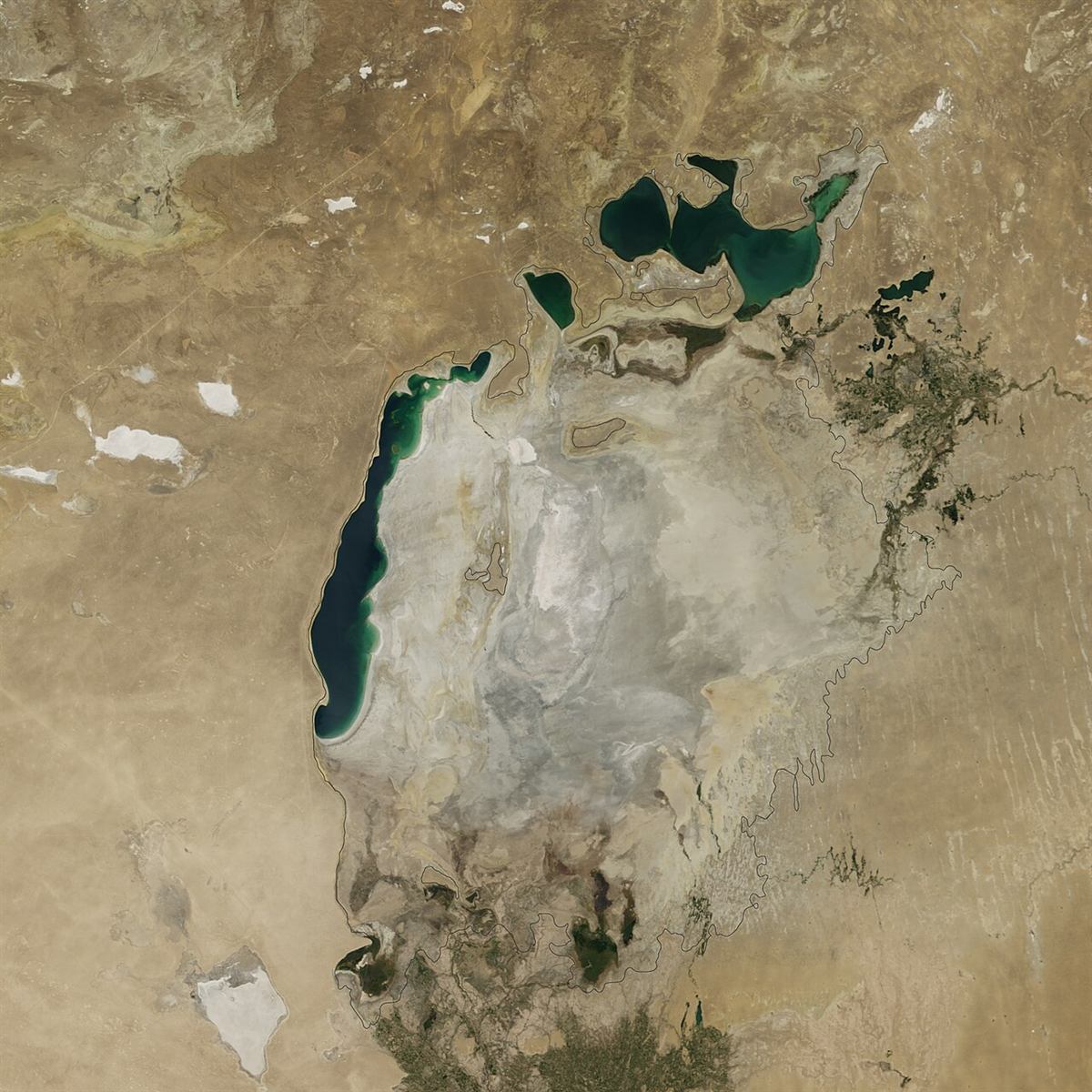
- The North and South Aral changed differently; one year's image is not the whole history
A sea between rivers and deserts
The Aral Sea was a terminal lake fed chiefly by the Amu Darya and Syr Darya. Its shores and deltas lie on both sides of the modern Uzbekistan–Kazakhstan border. Karakalpakstan is central to the story of the southern shore and lower Amu Darya, but the Aral region cannot be understood within one country's borders alone.
River courses, deltas and lake levels changed even before the twentieth century. Ancient sites therefore have to be studied alongside former channels and palaeogeographic evidence. Natural variation, however, cannot explain the scale and speed of the sea's late-twentieth-century retreat.
Changing the water balance
From the 1950s and 1960s, Soviet projects greatly expanded irrigated agriculture in both river basins, especially for cotton and rice. Water was diverted through canals, while inefficient distribution and drainage increased losses and soil salinity. Less river water reached the sea.
The World Bank links the decline to withdrawals, but the history also includes institutional decisions about crop plans, canal building, allocation among republics and farmers' dependence on irrigation. The word “drought” alone does not explain this change.
What satellites show
NASA and USGS image series allow shoreline comparisons across decades. By the early twenty-first century the sea had split into a northern part in Kazakhstan and a southern part associated with Uzbekistan; the South Aral then divided into western and eastern basins. The eastern basin dried completely in August 2014—an important event with a specific date.
NASA explains that the eastern basin varied from year to year with river flow, snow, rain and withdrawals. A 2014 image therefore does not mean that every part of the sea disappeared permanently. The North Aral and surviving parts of the South Aral have different histories; maps need an image date and a source.
Consequences for communities
Retreat changed fisheries, shipping and coastal settlements, including Muynak. The exposed bed left extensive saline and dust-producing surfaces. People in the Amu Darya delta had to adapt farming and water supplies to new conditions.
World Bank research describes salt-dust storms and impacts on soils and communities. It would still be wrong to attribute every individual illness solely to the drying sea: drinking water, poverty, medical care, nutrition and other factors matter. Precise health estimates require epidemiological studies that state their methods and periods.
Delta, restoration and limits
Planting vegetation on exposed seabed, improving irrigation and drainage, protecting delta wetlands and providing safe water address different problems. No single measure restores the shoreline of 1960. Regional cooperation must balance the environmental and social interests of several countries.
The Aral region's history is not only a disaster narrative. It is also a history of Karakalpak communities, scientific observation, economic decisions and attempts to live in a changed environment. Satellite data, local testimony and water-planning records are all needed to study it.
Sources
- NASA Earth Observatory — World of Change: Shrinking Aral Sea
- NASA Earth Observatory — The Aral Sea Loses Its Eastern Lobe (2014)
- USGS Earthshots — Aral Sea, Kazakhstan and Uzbekistan
- World Bank — The Value of Landscape Restoration in Uzbekistan to Reduce Sand and Dust Storms
- World Bank — Aral Sea Program, regional water management
- Wikimedia Commons — NASA satellite image and reuse status
